Field Station Network Corner-Stone Research Infrastructure Project "Multi-Tower-based LiDAR Platform for the Structure and Function of Secondary Forest Ecosystems" Passed Completion Assessment
During August 11 and 12, 2019, Bureau of Science and Technology for Development (BSTD), Chinese Academy of Sciences (CAS), administrated an Assessment Committee to field-assess the completion of Field Station Network Corner-Stone Research Infrastructure Project “Multi-Tower-based LiDAR Platform for the Structure and Function of Secondary Forest Ecosystems” (Abbreviation: Multi-Tower Platform; Project #: KFJ-SW-YW006, funded by CAS) in Qingyuan Forest CERN (Fig.1). The members in the Assessment Committee were CHEN Yiyu (Academician, National Natural Science Foundation of China), FU Bojie (Academician, Research Center for Eco-Environmental Sciences, CAS), FAN Weiming (Research Professor, Institute of Tibetan Plateau Research, CAS), HAN Xingguo (Research Professor, Institute of Botany, CAS), YU Guirui (Research Professor, Institute of Geographic Sciences and Natural Resources Research, CAS), WANG Kelin (Research Professor, Institute of Subtropical Agriculture, CAS), FENG Renguo (Research Professor, Institute of Semiconductor, CAS), HU Chunsheng (Research Professor, Institute of Genetics and Developmental Biology, CAS), and HE Honglin (Research Professor, Institute of Geographic Sciences and Natural Resources Research, CAS) (Fig. 2). The committee was authorized by CAS and the assessment processes were administrated by the CAS Administration Team. The team members were ZHANG Yaping (Vice-President of CAS, Academician), SUN Ming (Vice Director, BSTD), ZHOU Ju (Division Director), YANG Ping (Research Professor), and YANG Ming (Vice Division Director, CAS Office Bureau) (Fig. 2). The Institute of Applied Ecology (IAE), CAS, formed an IAE Reporting Group to address the accomplishments to the Assessment Committee and the CAS Administration Team. The members of IAE reporting Group were ZHU Jiaojun (Project Principal Investigator, Institute Director), JIN Changjie (Secretary of Party Committee), FANG Yunting (Institute Deputy Director), HAO Xin (Deputy Secretary of Party Committee), ZHUO Junchen (Secretary of Commission for Discipline Inspection), ZHOU Xinhua (Application Scientist, Campbell Scientific, US), and the major project members of project as well (Fig. 2). The total number of reporting group members was over 30. The completion assessment required two procedures: Field visit assessment and committee completion assessment.
Field visit assessment: ZHU Jiaojun presented the Assessment Committee and CAS Administration Team the construction accomplishments for the corner-stone research infrastructure of Multi-Tower Platform including the upgraded supporting research resources of long-term forest plot arrays, sub- and whole-watershed hydrology stations, data center, and other research sites (Fig. 3). While visiting, he briefed the project significances and design considerations to address the research topics on secondary forest ecosystems over mountainous terrains popular in the northeast. Xinhua Zhou explained the advancements of instrument configuration design and described the closed-path CO2/H2O eddy-covariance (EC) flux systems, atmospheric CO2/H2O profile systems, and other profiles of wind, air temperature, relative humidity, soil moisture, and soil temperature as well as other micrometeorology sensors. Dr. GAO Tian and CHEN Qingda (graduate student) demonstrated the LiDAR scanning operations in a vertically moving facility attached to individual towers.
Committee completion assessment: SUN Ming addressed the background of project and appointed CHEN Yiyu as the Chair of Assessment Committee in charge of the completion assessment. After detailed the background of Multi-Tower Platform to promote the cutting-edge research in secondary forest ecosystems over mountainous terrains, ZHU Jiaojun reported construction tasks, project accomplishments, platform operations, management protocols, funding uses, and platform functions to support multi-disciplinary research and inter-institutional collaborations. The team collaborations of current research based on this platform, ongoing research activities on the platform, and prospective research topics using this platform were also reported. Afterward, the Assessment Committee reviewed the official documents for the project, audited the funding records, questioned less apparent details, and recommended the strategies for future uses. The committee assessed the project-established Multi-Tower Platform as a corner-stone infrastructure able to acquire accurate, multiple-temporal and -spatial, and systematic data for secondary forest ecosystems. The project was executed as scheduled. The project completed four construction items: Multi-tower, LiDAR system, supplementary observation facilities (ECFlux systems and hydrologic stations), and data center. The fundamental constructions complied engineering standards. The installed instrumentation systems were running well in stable and reliable status. The records and documentations that were filed by the IAE Reporting Team met the requirements for completion assessment. The committee unanimously approved the completion of this project.
During the assessment, the committee suggested to enhance the collaboration with related field laboratory stations in Chinese Ecosystem Research Network (CERN), speed up the production of funded research projects, and promote the influence of production on the international forest and ecology community. For this corner-stone infrastructure, the committee also advocated IAE to develop an operation and management protocol, set a by-law for use, and advance sharing in use.
ZHANG Yaping presented closing remarks, hoping Qingyuan Forest CERN and BSTD to develop the policies of efficiently sharing the corner-stone infrastructure through opening the infrastructure to scientists for use domestically and internationally. Find a way to promote the influence of corner-stone infrastructure, contributing more to research activities. Enhance the establishment of corner-stone infrastructure systems and the ability to use network as a research tool. Along the road to establish the field stations and corner-stone infrastructure at the world-grade; broad views, aim at national major needs, propose creative ideas, develop new technologies, and lead the development of sciences and technologies; contributing our research to the social adoption of ecological civilization.
SUMMARY
Field Station Network Corner-Stone Research Infrastructure Project “Multi-Tower-based LiDAR Platform for the Structure and Function of Secondary Forest Ecosystems” (Project #: KFJ-SW-YW006; January 2016 to December 2018): To overcome the low accuracy in forest structure measurements, weak ability to acquire the structural descriptors, and the limited frequency of obtaining the descriptors over different micro-topographic forests; a project to establish a platform able to accurately monitor forest structure in a long-term was proposed to serve the research on forest ecosystem functions. This project established a multi-tower platform as a corner-stone infrastructure able to acquire accurate, multiple-temporal and -spatial, and systematic data for secondary forest ecosystems. The platform can be used for LiDAR forest structure measurements, CO2/H2O/trace gas flux measurements, micro-meteorology measurements inside and outside forest canopies, inventory measurements for forest growth and nutrient cycles, and hydrology monitoring over three sub-watersheds and over a closed watershed including these three sub-watersheds. Over these watersheds, the carbon sinks are measured using two approaches: Inventory method and eddy-covariance (EC) flux technique. The water input and output are measured in a closed watershed using meteorology method, EC flux techniques, and hydrology monitoring; therefore, carbon and water measurements in this platform are self-verifiable, which makes this platform rationale in design for research; reliable in research for data; and advanced in data acquisition for forest growth, carbon, water, and micrometeorology variables. The data from this platform can address the interactions among secondary forests, watershed hydrology process, and atmospheric transfer as a results of human disturbance, supporting the management to maintain and restore the structure and function of secondary forest ecosystems in water conservation and carbon sequestration and to ensure the northeast forest belt to be efficient, stable, and sustainable as a protection buffer for our society.
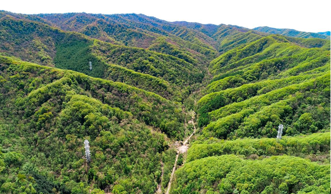
Fig. 1 The three towers facilitating studies on forest ecology and management over the watershed of Qingyuan Forest CERN (Chinese Ecosystem Research Network, Chinese Academy of Sciences) are located inside three forest sites categorized as naturaldeciduous broadleaved mixed forest (the left nearest tower), natural Mongolian oak forest (the right tower), and planted larch forest (the farthest tower). The three forests represent the three major types of secondary forest ecosystems in Northeast China.

Fig. 2 Field visit assessment on completion of “Multi-Tower-based LiDAR Platform for the Structure and Function of Secondary Forest Ecosystems” by Assessment Committee Chaired by CHEN Yiyu (Academician, 9th from left) including high profile scientists (e.g. FU Bojie, Academician, 10th from left) and Chinese Academy of Sciences (CAS) Administration Team led by ZHANG Yaping (Vice-President of CAS, Academician, 8th from left), both of which were accompanied by Institute of Applied Ecology Reporting Team led by Project Principal Investigator: ZHU Jiaojun (Institute Director, 7th from left).
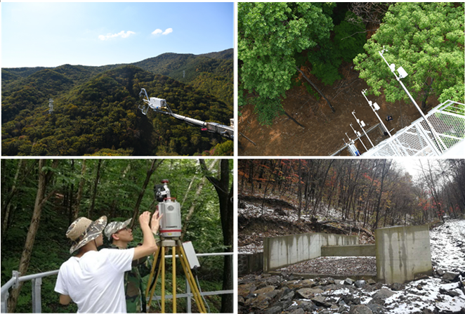
Fig. 3 Long-term measurement systems: Closed-path eddy-covariance flux measurement system (CPEC310, top left-panel), atmospheric profile system (AP200, top right-panel), tower-based LiDAR scanning operation (low left-panel), and watershed hydrology station (low right-panel).
| Download the attachment: |
