As the first layer of water retention, forest canopy redistributes rainfall into rainfall interception (RI), throughfall and stemflow. Generally, RI values range from 10% to 50% of rainfall in temperate forests, which can alleviate the kinetic energy of rainfall drops, and further mitigates soil erosion and floods, as well as influences water storage in litter and soil layers.
Therefore, the accurate quantification of RI interests environmental managers and ecologists. To address this issue, researchers have been looking for alternative ways to predict RI using vegetation variables such as leaf area index, plant area index and tree height. However, the abilities and performances of these variables are controversial, because these parameters have limitations primarily due to the weak explanation powers on the RI. Terrestrial laser scanning (TLS) is a state-of-the-art active remote sensing technology, which can offer an opportunity to quantify RI through describing the three-dimensional forest structures.
Recently, Dr. ZHU Jiaojun, Dr. GAO Tian and YU Yue, et al., from the Institute of Applied Ecology of the Chinese Academy of Sciences, defined a new dimensionless descriptor, canopy interception index (CII) for predicting RI. The Leaf, branch, and stem of the four forest types were separated by TLS cloud data, and their surface areas were estimated. Combined with specific water storage capacity of leaf, branch and stem, the CII was calculated and its applicability was examined (Figure 1). CII was strongly related with RI and explained 58% to 63% of the variations of RI. The CII’s performance was better than the other structural parameters, indicating it is an efficient index for predicting RI in temperate forests (Figure 2). The CII can be used to promote the performance of canopy interception model, as well as to provide a theoretical and practical reference for improving the forest water retention from a canopy aspect.
This study entitled “Terrestrial laser scanning-derived canopy interception index for predicting rainfall interception” has been published in Ecohydrology.
The finding achieved on the basis of Field Station Network Corner-Stone Research Infrastructure Project, named “Multi-Tower LiDAR/ECFlux Platform for the Structure and Function of Secondary Forest Ecosystems”. The work was financially supported by the Strategic Priority Research Program of the Chinese Academy of Sciences, National Natural Science Foundation of China and the Key Research Program of Frontier Sciences, Chinese Academy of Sciences.
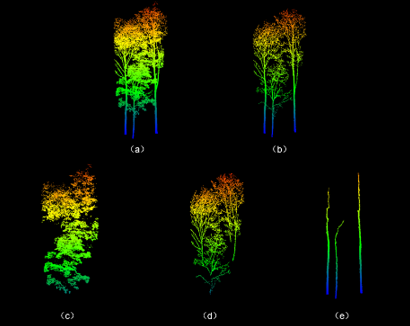
Figure 1 Comparison of point clouds before and after wood-leaf separations: (a) the leaf-on point clouds; (b) the leaf-off point clouds; (c) the separated leaf point clouds; (d) the separated branch point clouds; and (e) the separated stem point clouds (Image by GAO Tian).
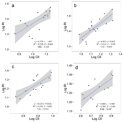
Figure 2 The log–log relationships between canopy interception index and rainfall interception for a given forest type: (a) Korean pine plantation forest, (b) larch plantation forest, (c) mixed broadleaved forest and (d) Mongolian oak forest. The solid blue lines are fit lines, whereas the grey bands show standard error of regression lines. NSE: Nash-Sutcliffe efficiency (Image by GAO Tian).
Publication Name: ZHU Jiaojun et al.
Email: yueqian@iae.ac.cn
