Ground-Penetrating Radar Reveals Optimal Tree Density to Combat Desertification in China’s Fragile Sandlands
A breakthrough study using ground-penetrating radar (GPR) has identified the optimal planting density for Mongolia pine plantations in China’s arid regions, offering a science-backed solution to combat tree die-offs threatening anti-desertification efforts.
The research, conducted on a long‐term trial in Zhanggutai, Liaoning Province, demonstrates that traditional methods based solely on aboveground indicators like canopy cover can overlook critical belowground interactions that ultimately govern plantation health.
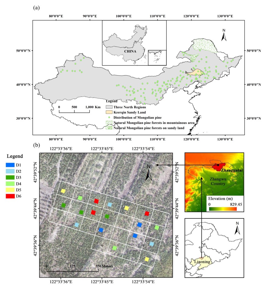
Researchers from the Chinese Academy of Sciences’ Institute of Applied Ecology have pinpointed the root cause behind the mysterious decline of Mongolia pine (Pinus sylvestris var. mongolica) plantations—a cornerstone of China’s "Three-North Shelterbelt" reforestation project (Figure 1a). Their findings, published in Forest Ecology and Management, reveal that overcrowded tree stands trigger fierce underground competition for water, accelerating forest degradation in semi-arid zones like the Horqin Sandy Land.
Mongolian pine, was introduced in 1955 for sand-fixing along the southern edge of the Horqin Sandland. However, after 35–40 years, many of these plantations have begun to decline, showing symptoms such as leaf yellowing, weakened growth, and increased pest infestations—a trend largely attributed to high initial planting densities and insufficient thinning practices. Recognizing that tree survival in arid and semi-arid regions relies fundamentally on root-mediated water and nutrient uptake, the study re-examines stand density from a belowground perspective.
Researchers utilized the Noggin 1000 GPR system alongside traditional soil coring to investigate coarse roots (>5 mm) and fine roots (<2 mm) in 25 trial plots, which originally ranged from 1,111 to 10,000 trees per hectare. Over 40 years of natural thinning led to six distinct density gradients, from 383 to 2,367 trees per hectare. The application of GPR allowed the team to quantify the spatial distribution of coarse roots non-destructively.
As stand density increased from 383 to 2,367 trees/hectare, the researchers found that coarse roots shortened horizontally from 3.65 m to 1.81 m while clustering more densely, but also that Coarse root depth decreased by 20% (95.3 cm to 75.8 cm), forcing trees into shallower, drier soil layers. Simultaneously, fine roots concentrated near the surface (0–20 cm), intensifying water competition. "Even the lowest density plot still showed root overlapping and intense root competition," noted lead researcher Dr. LI Mingjuan. "This proves why thinning is essential."
By establishing quantitative relationships between stand density and root competition intensity indicators,the researchers identified the optimum stand density (OSD) as being between 177 and 214 trees per hectare for 45-year-old plantations.
A notable advancement of this study is the implementation of GPR, which overcomes the limitations of earlier methods that were both laborious and destructive. GPR not only provides a swift and non-invasive means of mapping root distribution across large areas but also yields a more accurate picture of the belowground interactions that underpin tree competition and forest stand stability. This technological breakthrough marks a significant step forward in forest management, particularly in arid regions where water availability is a critical limiting factor.

Figure 1. Distribution of Mongolian pine plantations across China’s Three-North regions (a); white squares denote the 25 initial planting density trial plots, while coloured squares indicate the six stand density groups selected for this study (b).


